
Soubor:Stellardiagram-Zhengho.jpg
Velikost tohoto náhledu: 456 × 599 pixelů. Jiná rozlišení: 183 × 240 pixelů | 365 × 480 pixelů | 584 × 768 pixelů | 779 × 1 024 pixelů | 1 385 × 1 820 pixelů.
Původní soubor (1 385 × 1 820 pixelů, velikost souboru: 1,74 MB, MIME typ: image/jpeg)
| Tento soubor pochází z Wikimedia Commons. Níže jsou zobrazeny informace, které obsahuje jeho tamější stránka s popisem souboru. |
Popis
| Autor |
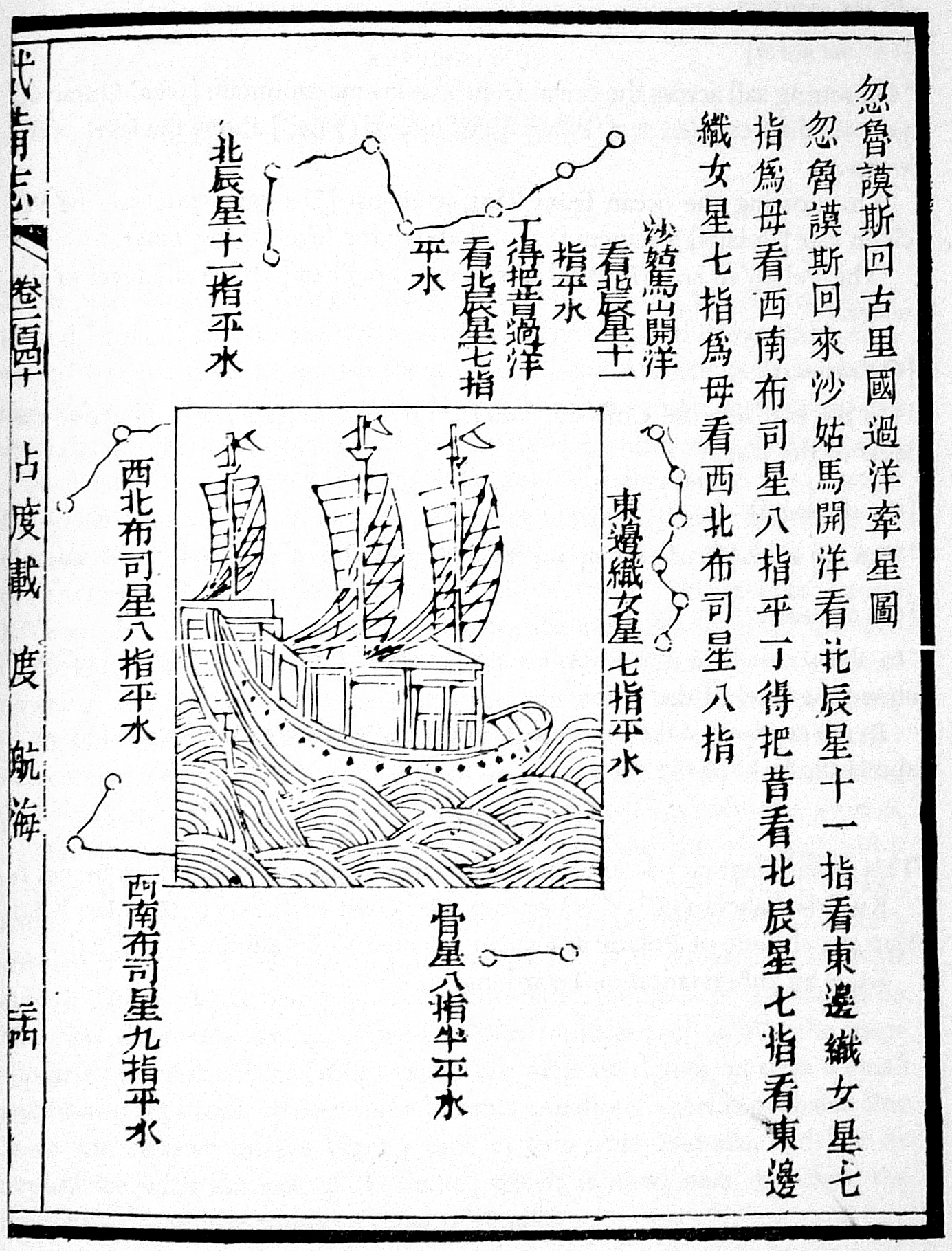
The author is unknown, but the charts were derived from works by Zheng He's expeditionary navigators during the early 15th century |
| Popis |
This navigational chart is one of the four stellar diagrams included in the Wubei Zhi, published in circa 1628. It appears in chapter 240, folio 24 r. The chart specifies the guiding stars enroute from Hormuz to Calicut. |
| Zdroj/Fotograf | Not given by uploader |
| Další verze |
|
| Reference | Mills, J.V.G. (1970). Ying-yai Sheng-lan: 'The Overall Survey of the Ocean's Shores' [1433]. pp. 335–346. |

Licence
|
Toto dílo je volné také v zemích, jejichž právní řád chrání majetková autorská práva po dobu života autora a 100 let po jeho smrti. | |
| Bylo zjištěno, že u tohoto souboru nejsou známa žádná omezení daná autorským právem a právy s ním souvisejícími. | |
Historie souboru
Kliknutím na datum a čas se zobrazí tehdejší verze souboru.
| Datum a čas | Náhled | Rozměry | Uživatel | Komentář | |
|---|---|---|---|---|---|
| současná | 1. 8. 2015, 21:32 | | 1 385 × 1 820 (1,74 MB) | Hzh | clearer image |
| 8. 12. 2005, 17:55 |  | 588 × 800 (78 KB) | Gisling | Admiral Zheng Ho's stellar navigation diagram |
Využití souboru
Tento soubor používají následující 2 stránky:
Globální využití souboru
Tento soubor využívají následující wiki:
- Využití na af.wikipedia.org
- Využití na ar.wikipedia.org
- Využití na ca.wikipedia.org
- Využití na el.wikipedia.org
- Využití na en.wikipedia.org
- Využití na es.wikipedia.org
- Využití na fr.wikipedia.org
- Využití na it.wikipedia.org
- Využití na ja.wikipedia.org
- Využití na pt.wikipedia.org
- Využití na ru.wikipedia.org
- Využití na sl.wikipedia.org
- Využití na test.wikipedia.org
- Využití na te.wikipedia.org
- Využití na uk.wikipedia.org
- Využití na vi.wikipedia.org
- Využití na zh.wikipedia.org