
Soubor:Spain and Portugal.png

Velikost tohoto náhledu: 800 × 411 pixelů. Jiná rozlišení: 320 × 164 pixelů | 640 × 329 pixelů | 1 024 × 526 pixelů | 1 500 × 771 pixelů.
Původní soubor (1 500 × 771 pixelů, velikost souboru: 92 KB, MIME typ: image/png)
| Tento soubor pochází z Wikimedia Commons. Níže jsou zobrazeny informace, které obsahuje jeho tamější stránka s popisem souboru. |
Popis

|
Tento obrázek (skupina map) by měl být vytvořen pomocí vektorové grafiky jako SVG soubor. To má několik výhod; podrobnosti najdete na stránce Commons:Media for cleanup. Je-li SVG verze tohoto obrázku již k dispozici, prosím nahrajte ji. Po nahrání nahraďte tuto šablonu šablonou {{Vector version available|jméno nového obrázku.svg}}.
|
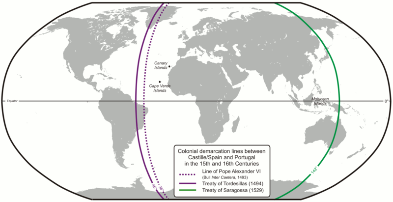
| Popis | Colonial demarcation lines between Castille/Spain and Portugal in the 15th and 16th Centuries. (Treaty of Tordesillas and Treaty of Saragossa) |
| Datum | |
| Zdroj | Vlastní dílo |
| Autor | Lencer |
| Další verze |
|


|
Tato mapa byla vytvořena nebo vylepšena v německé Kartenwerkstatt (Mapová laboratoř). Můžete také navrhnout mapy k vylepšení.
|
Licence
The map has been created with the Generic Mapping Tools: https://www.generic-mapping-tools.org/ using one or more of these public-domain datasets for the relief:
|

|
Tento dokument smí být kopírován, šířen nebo upravován podle podmínek Svobodné licence GNU pro dokumenty verze 1.2 nebo libovolné vyšší verze publikované nadací Free Software Foundation. Dokument nemá neměnné části ani texty na předním či zadním přebalu. Kopie textu licence je k dispozici v oddíle nazvaném GNU Free Documentation License. |
| Tento soubor podléhá licenci Creative Commons Uveďte autora-Zachovejte licenci 3.0 Unported | ||
| ||
| Tato licenční šablona byla k tomuto souboru přidána v rámci změny licencování. |
Historie souboru
Kliknutím na datum a čas se zobrazí tehdejší verze souboru.
| Datum a čas | Náhled | Rozměry | Uživatel | Komentář | |
|---|---|---|---|---|---|
| současná | 16. 2. 2013, 09:52 | | 1 500 × 771 (92 KB) | JohnnyMrNinja | indexed colors and increased compression |
| 7. 12. 2007, 11:10 |  | 1 500 × 771 (254 KB) | Lencer | {{Convert to SVG|map}} {{Information |Description= Karte der spanischen und portugiesischen Einflussbereiche nach den Verträgen von Tordesillas, Saragossa und [[:de:Vertrag von Alcaçovas|Alca |
Využití souboru
Tento soubor používají následující 3 stránky:
Globální využití souboru
Tento soubor využívají následující wiki:
- Využití na ar.wikipedia.org
- Využití na ast.wikipedia.org
- Využití na ca.wikipedia.org
- Využití na el.wikipedia.org
- Využití na en.wikipedia.org
- 1529
- Treaty of Tordesillas
- Portuguese Empire
- Spanish Empire
- Age of Discovery
- Spanish Canadians
- Slavery in colonial Spanish America
- Portuguese maritime exploration
- Alexandre de Gusmão
- List of territorial claims and designations in Colorado
- Territorial evolution of California
- Treaty of Zaragoza
- User:Mcapdevila/LatMaps
- User:Falcaorib/Spanish and Portuguese Empires
- Využití na en.wikivoyage.org
- Využití na eo.wikipedia.org
- Využití na es.wikipedia.org
- Využití na et.wikipedia.org
- Využití na fa.wikipedia.org
- Využití na fi.wikipedia.org
- Využití na fr.wikipedia.org
- Využití na hy.wikipedia.org
- Využití na id.wikipedia.org
- Využití na it.wikipedia.org
- Využití na ja.wikipedia.org
Zobrazit další globální využití tohoto souboru.