
Soubor:Plan Rome- Regiones.png

Velikost tohoto náhledu: 752 × 600 pixelů. Jiná rozlišení: 301 × 240 pixelů | 602 × 480 pixelů | 963 × 768 pixelů | 1 128 × 900 pixelů.
Původní soubor (1 128 × 900 pixelů, velikost souboru: 200 KB, MIME typ: image/png)
| Tento soubor pochází z Wikimedia Commons. Níže jsou zobrazeny informace, které obsahuje jeho tamější stránka s popisem souboru. |
| Popis |
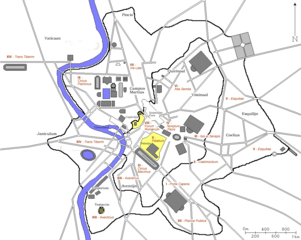
Nederlands: Kaart van antiek Rome. |
||
| Datum | 2006/2007 | ||
| Zdroj |
Nederlands: Kaart is afkomstig van Franstalige Wikipedia en door Joris1919 naar een Nederlandse versie bewerkt. |
||
| Autor | fr:User:ColdEel en nl:Gebruiker:Joris1919 | ||
| Svolení (Užití tohoto souboru) |
|
||
| Další verze | fr:Image:AmphitheatreCastrense_planrome.png |
Historie souboru
Kliknutím na datum a čas se zobrazí tehdejší verze souboru.
| Datum a čas | Náhled | Rozměry | Uživatel | Komentář | |
|---|---|---|---|---|---|
| současná | 30. 4. 2007, 21:18 | | 1 128 × 900 (200 KB) | Joris | {{Information |Description=Map of ancient Rome. |Source=Originally created for French Wikipedia Franstalige Wikipedia and edited by me to a Dutch version. |Date=2006/2007 |Author=fr:User:ColdEel en [[: |
| 30. 4. 2007, 21:16 |  | 1 128 × 900 (200 KB) | Joris | {{Information |Description=Map of ancient Rome. |Source=Originally created for French Wikipedia Franstalige Wikipedia and edited by me to a Dutch version. |Date=2006/2007 |Author=fr:User:ColdEel en [[: | |
| 21. 3. 2007, 17:08 |  | 1 128 × 900 (206 KB) | Joris | {{Information |Description=Kaart van antiek Rome. |Source=Kaart is afkomstig van Franstalige Wikipedia en door Joris1919 naar een Nederlandse versie bewerkt. |Date=2006/2007 |Author=fr:User:ColdEel en | |
| 3. 3. 2007, 12:11 |  | 1 128 × 900 (114 KB) | Evil berry | {{Information |Description=Kaart van antiek Rome. |Source=Kaart is afkomstig van Franstalige Wikipedia en door Joris1919 naar een Nederlandse versie bewerkt. |Date=2006/2007 |Author=fr:User:ColdEel en |
Využití souboru
Tento soubor používá následující stránka:
Globální využití souboru
Tento soubor využívají následující wiki:
- Využití na de.wikipedia.org
- Využití na el.wikipedia.org
- Využití na en.wikipedia.org
- Využití na he.wikipedia.org
- Využití na ja.wikipedia.org
- Využití na la.wikipedia.org
- Využití na nl.wikipedia.org
- Využití na pt.wikipedia.org
- Využití na ro.wikipedia.org
- Využití na zh.wikipedia.org