
Soubor:Kyrgyzstan provinces map.png
Větší rozlišení není k dispozici
Kyrgyzstan_provinces_map.png (750 × 423 pixelů, velikost souboru: 13 KB, MIME typ: image/png)
| Tento soubor pochází z Wikimedia Commons. Níže jsou zobrazeny informace, které obsahuje jeho tamější stránka s popisem souboru. |
Popis
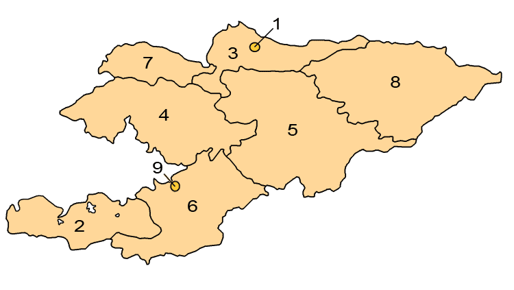
Map showing the provinces and districts of Kyrgyzstan, including the indepedent cities of Bishkek and Osh. This map is an updated version of Image:KyrgyzstanNumbered.png, which was created by w:en:user:Aivazovsky.
Licence

|
Tento dokument smí být kopírován, šířen nebo upravován podle podmínek Svobodné licence GNU pro dokumenty verze 1.2 nebo libovolné vyšší verze publikované nadací Free Software Foundation. Dokument nemá neměnné části ani texty na předním či zadním přebalu. Kopie textu licence je k dispozici v oddíle nazvaném GNU Free Documentation License. |
| Tento soubor podléhá licenci Creative Commons Uveďte autora-Zachovejte licenci 3.0 Unported | ||
| ||
| Tato licenční šablona byla k tomuto souboru přidána v rámci změny licencování. |
Historie souboru
Kliknutím na datum a čas se zobrazí tehdejší verze souboru.
| Datum a čas | Náhled | Rozměry | Uživatel | Komentář | |
|---|---|---|---|---|---|
| současná | 1. 4. 2008, 03:24 | | 750 × 423 (13 KB) | Hux | ==Summary== Map showing the provinces and districts of Kyrgyzstan, including the indepedent cities of Bishkek and Osh. This map is an updated version of Image:KyrgyzstanNumbered.png, which was created by w:en:user:Aivazovsky. ==Licensing== {{GFD |
Využití souboru
Tento soubor používají následující 4 stránky:
Globální využití souboru
Tento soubor využívají následující wiki:
- Využití na ace.wikipedia.org
- Využití na af.wikipedia.org
- Využití na ar.wikipedia.org
- Využití na arz.wikipedia.org
- Využití na az.wikipedia.org
- Využití na ca.wikipedia.org
- Využití na de.wikipedia.org
- Využití na en.wikipedia.org
- Využití na es.wikipedia.org
- Využití na eu.wikipedia.org
- Využití na fa.wikipedia.org
- Využití na fr.wikipedia.org
- Využití na he.wikipedia.org
- Využití na hi.wikipedia.org
- Využití na hr.wikipedia.org
- Využití na hu.wikipedia.org
- Využití na id.wikipedia.org
- Využití na is.wikipedia.org
- Využití na ja.wikipedia.org
- Využití na ka.wikipedia.org
- Využití na kk.wikipedia.org
Zobrazit další globální využití tohoto souboru.