
Soubor:Australian external territories.png
Větší rozlišení není k dispozici
Australian_external_territories.png (644 × 376 pixelů, velikost souboru: 14 KB, MIME typ: image/png)
| Tento soubor pochází z Wikimedia Commons. Níže jsou zobrazeny informace, které obsahuje jeho tamější stránka s popisem souboru. |

|
Tento obrázek (skupina locator map) by měl být vytvořen pomocí vektorové grafiky jako SVG soubor. To má několik výhod; podrobnosti najdete na stránce Commons:Media for cleanup. Je-li SVG verze tohoto obrázku již k dispozici, prosím nahrajte ji. Po nahrání nahraďte tuto šablonu šablonou {{Vector version available|jméno nového obrázku.svg}}.
|
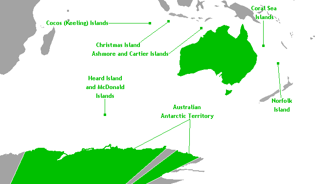
Popis
This is a map of Australia's external territories. The base map is Image:Antarctica territorial claims.png by User:Astrokey44 since it shows the AAT. The location of the other territories is Image:BlankMap-World-v6.png by the same user. The previous maps are under the GFDL; therefore, this map is too.
Licence
Já, držitel autorských práv k tomuto dílu, ho tímto zveřejňuji za podmínek následujících licencí:

|
Tento dokument smí být kopírován, šířen nebo upravován podle podmínek Svobodné licence GNU pro dokumenty verze 1.2 nebo libovolné vyšší verze publikované nadací Free Software Foundation. Dokument nemá neměnné části ani texty na předním či zadním přebalu. Kopie textu licence je k dispozici v oddíle nazvaném GNU Free Documentation License. |
| Tento soubor podléhá licenci Creative Commons Uveďte autora-Zachovejte licenci 3.0 Unported | ||
| ||
| Tato licenční šablona byla k tomuto souboru přidána v rámci změny licencování. |
Můžete si zvolit libovolnou z těchto licencí.
Historie souboru
Kliknutím na datum a čas se zobrazí tehdejší verze souboru.
| Datum a čas | Náhled | Rozměry | Uživatel | Komentář | |
|---|---|---|---|---|---|
| současná | 18. 11. 2010, 08:40 | | 644 × 376 (14 KB) | Hoshie | rm boundary lines in Africa, SE Asia, and PNG to focus on Australia and its territories; fixed color of the Comoros |
| 17. 3. 2007, 12:00 |  | 644 × 376 (14 KB) | Hoshie | This is a map of Australia's external territories. The base map is Image:Antarctica territorial claims.png by User:Astrokey44 since it shows the AAT. The location of the other territories is Image:BlankMap-World-v6.png by the same user. The |
Využití souboru
Tento soubor používá následující stránka:
Globální využití souboru
Tento soubor využívají následující wiki:
- Využití na af.wikipedia.org
- Využití na az.wikipedia.org
- Využití na ba.wikipedia.org
- Využití na be.wikipedia.org
- Využití na br.wikipedia.org
- Využití na bs.wikipedia.org
- Využití na de.wikipedia.org
- Využití na en.wikipedia.org
- Využití na eo.wikipedia.org
- Využití na gl.wikipedia.org
- Využití na hi.wikipedia.org
- Využití na hy.wikipedia.org
- Využití na incubator.wikimedia.org
- Využití na ka.wikipedia.org
- Využití na ko.wikipedia.org
- Využití na lv.wikipedia.org
- Využití na mr.wikipedia.org
- Využití na oc.wikipedia.org
- Využití na pa.wikipedia.org
- Využití na ru.wikipedia.org
- Využití na ru.wikinews.org
- Využití na sh.wikipedia.org
- Využití na simple.wikipedia.org
- Využití na sk.wikipedia.org
- Využití na sr.wikipedia.org
- Využití na ta.wikipedia.org
- Využití na th.wikipedia.org
- Využití na tr.wikipedia.org
- Využití na vec.wikipedia.org
- Využití na war.wikipedia.org
- Využití na xmf.wikipedia.org
- Využití na zh.wikipedia.org